
Projects
Transportation - Rail
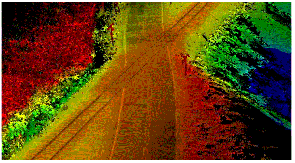
Our GIS Rail Asset Management Program focuses on the thorough field verification of assets ensuring accurate data, representation and reporting.
-
Asset Inventory and Condition Assessment:
-
Rail Infrastructure:
-
This involves identifying and documenting rail-related assets, including tracks, bridges, tunnels, signaling systems, warning/control devices and other infrastructure components. :
-
Creating a comprehensive record of all assets, including their location and condition.
-
-
-
Encroachment Assessment:
-
Identification:
-
Detecting any structures, utilities, or activities that encroach on the railroad's right-of-way, such as pipelines, power lines or unauthorized access.
-
-
-
Reporting and Documentation:
-
Detailed Reports.
-
Creating comprehensive reports that document the assessment findings, including asset condition and encroachment locations.
-
-
GIS Systems:
-
Using Geographic Information Systems (GIS) to map and visualize asset locations, encroachments, and other relevant data using mobile data collection techniques.
-
-

Oil Spill Resonse
We have extensive experience in emergency response operations, having actively participated in coastal emergency response, notably during the Cosco Busan incident.
Our work included:
-
Shoreline Cleanup Assessment Technique (SCAT) in combination with NOAA and the California Department of Fish and Game..
-
Tracking personnel in the field
-
Chronicling the daily coastal oil recovery numbers
-
Creating daily wall (war) maps for the EOC to view each morning.

Hydrocarbon Contamination Monitoring
-
We conducted scattered data interpolation to calculate contaminated groundwater for hydrocarbon remediation at or near storage facilities.
-
We created up to date maps and data on contamination (benzene, toluene and xylene) levels at each monitoring well, based on regular observations at specified intervals..
-
As contamination was remediated the historical data could show progress in remediation as well as predicted flow patterns in the ground water.

Hazardous Liquid Pipelines
-
We have performed overland flow analysis for liquid pipelines to conduct High Consequence Areas (HCA) analysis..
-
We managed both current historical HCA analysis reports within a SQL database for auditing federal reports.
-
Created spatial queries in PODS to support PHMSA Annual reports and ensured data quality maintenance for the PODS database.
-
Managed GIS data to facilitate state and fedetral submissions through ARCGIS Portal Dashboards.
-
We collaborated with various business units to develop integrated GIS solutions using Survey 123 forms and custom SQL databases for the observation results.
-
We can assist in or submit regulatory documents to TxDOT, NPMS and PHMSA.